×
MindLuster Logo

Land area measurement in mobile for beginners

Track :

Engineering

Lessons no : 3

For Free Certificate After Complete The Course

To Register in Course you have to watch at least 30 Second of any lesson

Join The Course Go To Community Download Course Content

What will you learn in this course?
  • Master land surveying principles using mobile apps and GPS technology for accurate land measurement and mapping
  • Utilize digital mapping tools and satellite imagery to enhance precision in land area measurement tasks
  • Apply best practices for mobile land surveying, including troubleshooting common measurement challenges
  • Perform practical land measurement tasks for agriculture, real estate, and construction using smartphones and tablets

How to Get The Certificate

  • You must have an account Register
  • Watch All Lessons
  • Watch at least 50% of Lesson Duration
  • you can follow your course progress From Your Profile
  • You can Register With Any Course For Free
  • The Certificate is free !
Lessons | 3


We Appreciate Your Feedback

Excellent
17 Reviews
Good
11 Reviews
medium
1 Reviews
Acceptable
0 Reviews
Not Good
0 Reviews
4.6
29 Reviews

Anushka Mohite

Great one
2025-10-30

Francisco Javier Espinoza Aguaida

Muy bien explicado y muy didáctico.
2025-10-12

Abhishek Rathod

Nice
2025-10-12

Super Man

Good
2025-10-10

Amit Chavan

Amazing
2025-10-09

Samarth Nt

No comments
2025-10-09

NANTHINI S

Very useful
2025-10-08

Viswanathan

GOOD
2025-09-28

UVARAJA R.

good
2025-09-27

Miktesfa21

Good
2025-09-03

adil ali

i like this platform
2025-08-16

Vaishnavi Gahininath Kekan

Very helpful
2025-07-05

Show More Reviews

Our New Certified Courses Will Reach You in Our Telegram Channel
Join Our Telegram Channels to Get Best Free Courses

Join Now

Related Courses

Land area measurement in mobile course, 
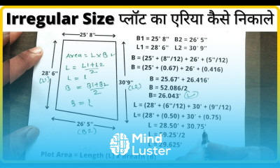
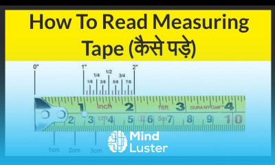
in this course we will learn about the innovative methods and tools for accurately measuring land areas using mobile devices. This course covers the fundamental principles of land surveying, focusing on the use of mobile apps and GPS technology to measure and map land areas with precision. Students will explore various mobile tools and applications designed for land area measurement, including their features, functionalities, and best practices for use. Key topics include GPS-based measurement techniques, digital mapping, and the integration of satellite imagery for enhanced accuracy. Practical sessions will provide hands-on experience in using smartphones and tablets for land surveying tasks, from agricultural land measurement to real estate and construction site mapping. The course will also address common challenges in mobile land measurement and troubleshooting methods. By the end of the course, participants will be equipped with the knowledge and skills to efficiently perform land area measurements using mobile devices, making it ideal for surveyors, real estate professionals, and anyone involved in land management and development.