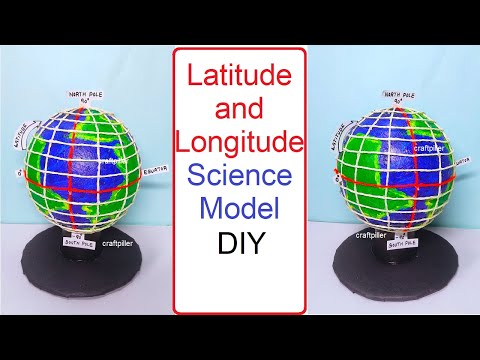
Course Description
Making 3d earth globe model,
in this course provides students with a creative and practical way to understand our planet’s geography and structure. In this course, learners build a 3D globe that displays continents, oceans, and important geographical features, helping them visualize the Earth as a whole rather than through flat maps. By constructing the model, students gain knowledge of latitude, longitude, hemispheres, and the positioning of countries, enhancing their spatial awareness. The project also explains Earth’s rotation and revolution, linking the globe to day, night, and seasons. Using simple and colorful materials, learners design an engaging globe that makes geography interactive and fun. This activity develops problem-solving, creativity, and presentation skills while strengthening scientific and geographical understanding. Ideal for classroom learning, exhibitions, and science fairs, the course transforms abstract concepts into tangible learning experiences, encouraging students to appreciate Earth’s beauty, diversity, and importance as our shared home. howtofunda